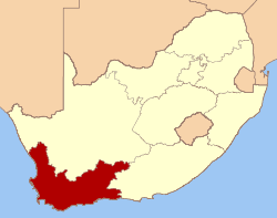
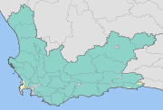
Western Cape
| Western Cape Wes-Kaap (Afrikaans) Ntshona-Koloni (Xhosa) |
|||
|---|---|---|---|
| — Province of South Africa — | |||
| The Province of the Western Cape | |||
|
|||
| Motto: Spes Bona (Good Hope) | |||
 |
|||
| Country | |||
| Established | 27 April 1994 | ||
| Capital | Cape Town | ||
| Districts |
List
City of Cape Town
West Coast Cape Winelands Overberg Eden Central Karoo |
||
| Government | |||
| - Type | Parliamentary system | ||
| - Premier | Helen Zille (DA) | ||
| Area[1] | |||
| - Total | 129,370 km2 (49,950 sq mi) | ||
| Area rank | 4th in South Africa | ||
| Highest elevation | 2,325 m (7,628 ft) | ||
| Lowest elevation | 0 m (0 ft) | ||
| Population (2007)[2] | |||
| - Total | 5,278,585 | ||
| - Rank | 4th in South Africa | ||
| - Density | 40.8/km2 (105.7/sq mi) | ||
| - Density rank | 5th in South Africa | ||
| Population groups[3] | |||
| - Coloured | 50.2% | ||
| - Black African | 30.1% | ||
| - White | 18.4% | ||
| - Indian or Asian | 1.3% | ||
| Languages[4] | |||
| - Afrikaans | 55.3% | ||
| - Xhosa | 23.7% | ||
| - English | 19.3% | ||
| Time zone | SAST (UTC+2) | ||
| ISO 3166 code | ZA-WC | ||
| Website | capegateway.gov.za | ||
The Western Cape is a province in the south west of South Africa. The capital is Cape Town. Prior to 1994, the region that now forms the Western Cape was part of the much larger (and now defunct) Cape Province. Prior to the formation of the Union of South Africa in 1910, it was called the Cape Colony (see the History of Cape Colony).
Contents |
History since 1994
In 1994, after the inauguration of South Africa's first black president, Nelson Mandela, the Cape Province was broken up into three provinces: Western Cape, Northern Cape and Eastern Cape (which encompasses the former Xhosa homelands of Transkei and Ciskei). However, the Western Cape set itself apart early in post-apartheid South African history by being one of the two provinces to have rejected an ANC mandate (the other being KwaZulu-Natal) by electing former South African Law and Order minister Hernus Kriel (NP) as the first premier of the Western Cape. It would be dominated by the National Party, and its successor, until the party's announced 2004 merger with the ANC, which brought ex-premier Ebrahim Rasool to power.
Law and government
The capital of the Western Cape is the City of Cape Town. The Premier of the Western Cape is Helen Zille[5] while the Director-General of the provincial administration is Virginia Petersen[6].
The Constitution of the Western Cape was adopted in 1998 and is published in the official languages of the province: Afrikaans, English and Xhosa.
The Western Cape Provincial Parliament is responsible for creating laws within its responsibilities as set out by the South African Constitution. Some of the issues dealt with cover agriculture, education, environment, health services, housing, language policies, tourism, trade, and welfare. It is housed in Cape Town and has a total of 42 members. The Fourth Provincial Parliament was elected in the election of 22 April 2009; 22 seats are held by the Democratic Alliance, 14 by the African National Congress, 3 by the Congress of the People, 2 by the Independent Democrats, and 1 by the African Christian Democratic Party.
Geography
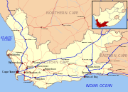
The Western Cape is bordered on the north by the Northern Cape, on the east by the Eastern Cape, on the south by the Indian Ocean, and on the west by the Atlantic Ocean. The subantarctic dependency of the Prince Edward Islands is included within the province's administration. The Breede, Berg and Olifants Rivers are major rivers of the province. The capital is Cape Town and other major cities include Stellenbosch, Worcester, Paarl, and George. The Garden Route and the Overberg are popular coastal tourism areas.
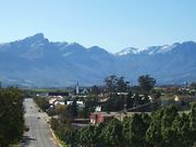
The Western Cape is exceptionally topographically diverse. Most of the province falls within the Cape Fold Belt, a range of sandstone folded mountains of Permian to Carboniferous age that range in height from 1000m to 2300m. The valleys between ranges are generally very fertile and contains alluvial loamy to clay soils. The far interior forms part of the Karoo Basin and is generally arid and hilly with a sharp escarpment in the north. Coastal areas range from sandy between capes, to rocky to steep and mountainous in places. The Western Cape is also the southernmost region of the African continent with Cape Agulhas as its southernmost point, only 3800km from the Antarctic coastline.
The total land area is 129,370 km², about 10.6% of the country’s total. It is roughly the size of England or the US state of Louisiana.
Vegetation is also extremely diverse, with one of the world's seven floral kingdoms almost exclusively endemic to the province, namely the Cape Floral Kingdom, most of which is covered by Fynbos (Afrikaans: Fine Bush). It is extremely rich in species diversity, with more plant species occurring on Table Mountain than the entire United Kingdom. It is characterised by various types of shrubs, thousands of flowering plant species and some small trees.
The arid interior is dominated by Karoo drought-resistant shrubbery. The West Coast and Little Karoo are semi-arid regions and are typified by many species of succulents and drought-resistant shrubs and acacia trees. The Garden Route is extremely lush, with temperate rainforest (or Afromontane Forest) covering many areas adjacent to the coast and along the mountain ranges. Typical species are hardwoods of exceptional height, such as Yellowwood, Stinkwood and Ironwood trees.
Municipalities
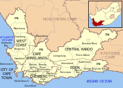
The Western Cape is made up of one metropolitan municipality, and five district municipalities subdivided into 24 local municipalities.
|
|
Cities and towns
The population figures quoted only include urbanised areas:
Population 1,000,000++
Population 50,000+
|
|
Population 10,000+
|
|
|
|
Population < 10,000
|
|
Climate
The Western Cape is also diverse climatologically, with many distinct micro- and macroclimates created by the varied topography and the influence of both the Indian (warm water) and Atlantic (cold water) oceans, thus climatic statistics can vary greatly over short distances. Most of the province is considered to have a Mediterranean climate with cool, wet winters and warm, dry summers. The interior Karoo has a semi-arid climate with cold, frosty winters and hot summers with occasional thunderstorms. The Garden Route and the Overberg on the south coast have a maritime climate with cool, moist winters and mild, moist summers. Mossel Bay in the Garden Route is considered to have the second mildest climate worldwide after Hawaii.
Thunderstorms are generally rare in the province, except in the Karoo interior, with most precipitation being of a frontal or orographic nature. Extremes of heat and cold are common inland, but rare near the coast. Snow is a common winter occurrence on the higher lying ground, however frost is relatively rare in coastal areas and many of the heavily cultivated valleys.
The dependency of the Prince Edward Islands are subantarctic islands, which experience year-round cool to cold temperatures with high precipitation and little annual deviation on both accounts.
- Cape Town Int'l Airport averages: January maximum: 26°C (min: 16°C), July maximum: 18°C (min: 7°C), annual rainfall: 515mm
- Kirstenbosch, Cape Town annual rainfall: 1395mm
- George averages: January maximum: 25°C (min: 15°C), July maximum: 19°C (min: 7°C), annual rainfall: 715mm
- Marion Island (Prince Edward Group) averages: January maximum: 10°C (min: 5°C), July maximum: 6°C (min: 1°C), annual rainfall: 2401mm
Economy
The Western Cape's total GDP is the third-highest contribution to the country’s total, at 14.6%. The largest industry is the clothing and textile industry, which employs over 170,000 people. The textile industry is presently declining in importance, due to competition with cheaper Eastern producers, such as China. High-tech industries, international call centres, fashion design, advertising and TV production are niche industries rapidly gaining in importance. The province also has a substantially lower unemployment rate than the other provinces; 17.1% of the working population is unemployed.
The province has recently grown a massive tourism industry, with the majority of international tourist arrivals visiting the province, with Cape Town, Garden Route and the Winelands being popular tourist destinations. There were 1,535,903 international arrivals in 2004 with continued growth annually. Domestic tourism is also on the rise, as low-cost air carriers such as Kulula and 1Time making travel more affordable to more South Africans.
Infrastructure and communications
The Western Cape has an excellent network of highways comparable with any first-world country. The primary highways are the N1 (from Cape Town to Three Sisters, continuing outside the province towards Bloemfontein and Johannesburg), N2 (from Cape Town to Bloukrans River, towards Port Elizabeth), N7 (from Cape Town to Bitterfontein, continuing towards Springbok and Namibia) and N12 (from George to Three Sisters, continuing towards Kimberley and Johannesburg). Other routes are the "R" roads which connect the smaller towns. All major roads are tarred with major rural gravel roads well maintained. Limited access motorways are limited to the Cape Metropolitan Area, Winelands and Garden Route, however due to the low population density of the remainder of the province, the highways remain efficient and high-speed, except during peak holiday travel seasons, when travel can be slow-going in places due to heavy traffic.
Telecommunications in the province is highly sophisticated; however, landline telephone communications still leaves much to be desired (much due to the Telkom telecommunications parastatal's monopoly). All areas have internet access. Mobile cellular communications is world class with reception in all densely populated rural areas, all urban areas and along all major routes (including mountain passes and tunnels). All national banks are represented almost everywhere, including even the smallest of towns.
Demographics
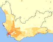
| <1 /km² 1–3 /km² 3–10 /km² 10–30 /km² 30–100 /km² | 100–300 /km² 300–1000 /km² 1000–3000 /km² >3000 /km² |
As of the census of 2001,[7] there were 4,524,336 people in the Western Cape, living in 1,173,302 households. The population density was 34.97/km² and the household density 9.07/km². In terms of race, 53.91% of people described themselves as Coloured, 26.68% as Black, 18.41% as White, and 1.00% as Indian or Asian 1.00%.
Age distribution in the province is spread out, with 27.3% under the age of 15, 19.4% from 15 to 24, 32.9% from 25 to 44, 15.2% from 45 to 64, and 5.2% who are 65 years of age or older. The median age is 26 years. For every 100 females there are 94.0 males. For every 100 females age 18 and over, there are 91.3 males.
In the province 55.3% of residents speak Afrikaans at home, 23.7% speak Xhosa, 19.3% speak English, and less than 2% speak another language.
81.8% of residents are Christian, 9.0% have no religion, 6.5% are Muslim, 0.4% are Jewish, and 0.2% are Hindu. 2.1% have other or undetermined beliefs.
5.7% of residents aged 20 and over have received no schooling, 15.2% have had some primary school, 7.9% have completed only primary school, 36.5% have had some high school education, 23.4% have finished only high school, and 11.2% have an education higher than the high school level. Overall, 34.6% of residents have completed high school.
63.1% of housing units have a telephone and/or cell-phone in the dwelling, 34.2% have access to a phone nearby, and 2.7% have access that is not nearby or no access. 86.5% of households have a flush or chemical toilet. 87.8% have refuse removed by the municipality at least once a week and 1.4% have no rubbish disposal. 67.5% have running water inside their dwelling, 85.2% have running water on their property, and 98.3% have access to running water. 78.8% of households use electricity for cooking, 73.4% for heating, and 88.0% for lighting. 79.1% of households have a radio, 74.1% have a television, 18.2% own a computer, 73.5% have a refrigerator, and 41.4% have a cell-phone.
17.1% of the population aged 15-65 is unemployed. Of the unemployed persons, 53.4% are Black, 43.0% are Coloured, 0.4% are Indian/Asian, and 3.2% are White. 23.3% of Black are unemployed, 9.3% of Coloureds, 5.0% of Indians/Asians, and 2.0% of Whites.
The median annual income of working adults aged 15-65 in the Western Cape is R 18,703. Males have a median annual income of R 21,048 versus R 17,035 for females. The median annual income by race is R 12,213 for Blacks, R 16,354 for Coloureds, R 42,803 for Indians/Asians, and R 64,968 for Whites. The annual income distribution is:
| No income | 2.0% |
| R 12 – R 4,800 | 6.5% |
| R 4,812 – R 9,600 | 17.7% |
| R 9,612 – R 19,200 | 25.1% |
| R 19,212 – R 38,400 | 20.1% |
| R 38,412 – R 76,800 | 15.2% |
| R 76,812 – R 153,600 | 8.3% |
| R 153,612 – R 307,200 | 3.3% |
| R 307,212 – R 614,400 | 1.1% |
| R 614,412 or more | 0.7% |
Education
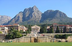
The Western Cape is the most highly educated province with a very skilled workforce in comparison to any other African region.[8] The high school graduation rate is consistently around 80%, higher than any other province. The province also boasts three internationally acclaimed universities, namely the University of Cape Town, Stellenbosch University and the University of the Western Cape.
- Universities
- Stellenbosch University
- University of Cape Town
- University of the Western Cape
- Cape Peninsula University of Technology
- Other Educational Institutions
- South African Military Academy
References
- ↑ Burger, Delien, ed (2009). "The land and its people". South Africa Yearbook 2008/09. Pretoria: Government Communication & Information System. p. 8. ISBN 978-0-621-38412-3. http://www.gcis.gov.za/resource_centre/sa_info/yearbook/2009/chapter1.pdf. Retrieved 23 September 2009.
- ↑ "Community Survey 2007: Basic results" (PDF). Statistics South Africa. p. 2. http://www.statssa.gov.za/publications/CS2007Basic/CS2007Basic.pdf. Retrieved 23 September 2009.
- ↑ "Statistical release P0301: Community Survey, 2007 (Revised version)" (PDF). Statistics South Africa. p. 25. http://www.statssa.gov.za/publications/P0301/P0301.pdf. Retrieved 7 October 2009.
- ↑ "Table: Census 2001 by province, language, population group and gender.". Census 2001 Interactive Tables. Statistics South Africa. http://www.statssa.gov.za/timeseriesdata/pxweb2006/Dialog/varval.asp?ma=Language%20by%20province&ti=Table%3A+Census+2001+by+province%2C+language%2C+population+group+and++gender%2E&path=../Database/South%20Africa/Population%20Census/Census%202001%20-%20NEW%20Demarcation%20boundaries%20as%20at%209%20December%202005/Provincial%20level%20-%20Persons/&lang=1. Retrieved 28 January 2010.
- ↑ "Applause as Zille secures premiership". IOL. 6 May 2009. http://www.iol.co.za/index.php?art_id=nw20090506124045976C370668. Retrieved 6 May 2009.
- ↑ "Ms Virginia Petersen". Cape Gateway. Provincial Government of the Western Cape. http://www.capegateway.gov.za/eng/gov_employees/7410. Retrieved 29 December 2008.
- ↑ "Census 2001". Statistics South Africa. http://www.statssa.gov.za/census01/html/default.asp.
- ↑ "Skilled Workforce reference". South African Department of Sport And Recreation. http://www.za-ydf.org/displaysection.php?czacc=&zSelectedSectionID=sec1246950242.
External links
- Provincial Government of the Western Cape
- Western Cape Tourism
- Western Cape Investment and Trade Promotion Agency
|
||||||||||||||||||||||
|
|||||||||